Franz Xaver Veigl, Map of the Amazon River (1785)
Abstract
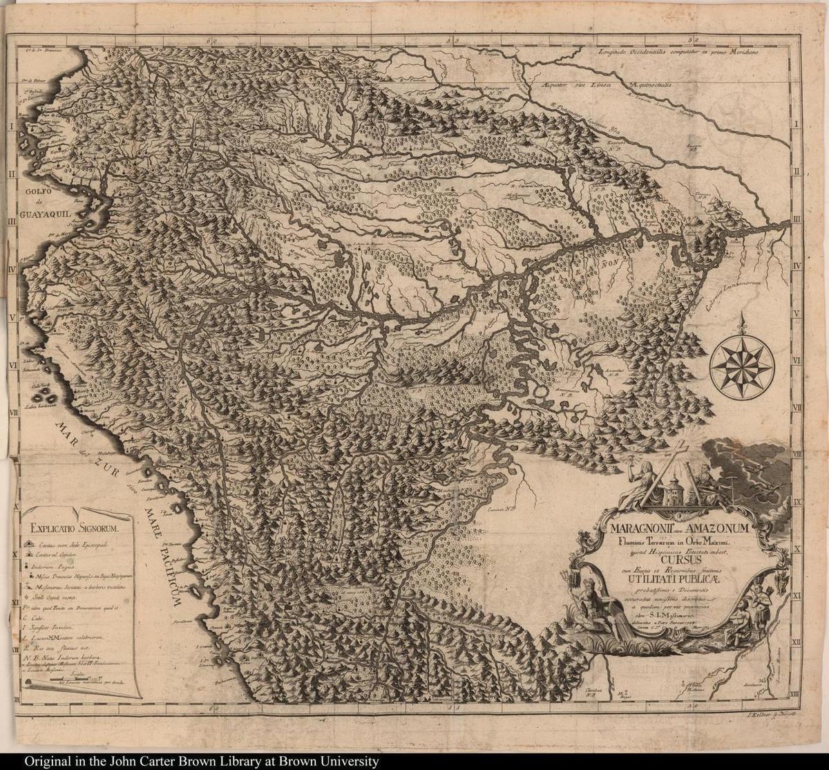
Father Franz Xaver Veigl was a Jesuit missionary in the so-called Maynas mission (in modern-day Peru). He was expelled in 1767 as part of the suppression of the Jesuit order in the Spanish Empire. His map of the mission’s territory was published in 1785 in Nuremberg by Christoph Gottlieb von Murr, a Protestant who admired the scientific achievements of the Jesuits and defended them vehemently against their critics. The map was published together with a report on the landscape and topography of Maynas [Gründliche Nachrichten über die Verfassung der Landschaft von Maynas]. In this report, Veigl explains that his map was based on other maps and texts as well as his own empirical observations of river systems in the Upper Amazon region.
Source
Excerpt from pages 6-8
The enclosed map can certainly be considered the most accurate of all those that have represented these countries up to now. As the basis, I took in part the small map by Mr. [Charles Marie] de la Condamine, showing the course of the Marañón River in general, in part that of the former General Procurator of Quinto, P. [Father] Carlos Brentano, which he had engraved in Rome in around 1751. Then, to either supplement or improve the two, I traced with the greatest possible care that large map, almost unknown in Germany, which Don Pedro Maldonado produced from the observations of Spanish and French academics about Quinto and Peru, and which Mr. [Jean Baptiste Bourguignon] d’Anville also follows in his large general map of America. Beyond this, I at times supplemented, at times corrected all the deficits or errors that I had found years ago in all the aforementioned [maps], based in part on my own long observation and in part on manuscripts and drawings relating to the area [created] by well-informed men. My efforts will be sufficiently rewarded if the reader finds in them not only pleasant diversion but also various materials that prompt admiration for the treasures created by the All-Powerful and recognition of the praiseworthy aspects of wisest foresight, and as well, to take to heart the state of those peoples, in the Christian spirit.
Source: Franz Xaver Veigl, “Gründliche Nachrichten über die Verfassung der Landschaft von Maynas,” in Christoph Gottlieb von Murr, Reisen einiger Missionarien der Gesellschaft Jesu in Amerika: mit einer Landkt. u. Kupfern. Nürnberg: Bey Johann Eberhard Zeh, 1785, pp. 6-8.
Translation: Kathleen Dell’Orto
Source: Franz Xaver Veigl, "Gründliche Nachrichten über die Verfassung der Landschaft von Maynas," in Christoph Gottlieb von Murr, Reisen einiger Missionarien der Gesellschaft Jesu in Amerika: mit einer Landkt. u. Kupfern. Nürnberg: Bey Johann Eberhard Zeh, 1785. John Carter Brown Library. Available online at: https://jcb.lunaimaging.com/luna/servlet/s/65lj9l
Further Reading
Miguel de Asúa, Science in the Vanished Arcadia. Knowledge of Nature in the Jesuit Missions of Paraguay and Río de la Plata. Leiden and Boston: Brill, 2014.
Irina Pawlowsky, “Von barbarischen Ländern, wilden Flüssen und weißen Flecken. Die Karte des Río Marañón von Franz Xaver Veigl,” in Esther Schmid Heer, Nikolaus Klein, and Paul Oberholzer, eds., Transfer, Begegnung, Skandalon? Neue Perspektiven auf die Jesuitenmissionen in Spanisch-Amerika. Stuttgart: Kohlhammer, 2019.