NS-Propaganda Map on the “Resettlement” of “Ethnic Germans” (January 1941)
Abstract
Original title: The undirected eastward emigration of German peasants and citizens and the planned resettlement into Adolf Hitler's Greater German People's Empire. Presented in cooperation with the Office for Training Circulars by Christof Silbermann, Munich. Supplement to the special publication: “German Blood Returns Home.” Published by: The Reich Organization Leader - Main Education Office, Munich 33, Barerstrasse 15.
Source
This map shows in black the exact location of the German settlements in the eastern region whose inhabitants have been caught up in the great resettlement of our days. The black emigration lines (drawn differently according to homeland areas) tell us the origin of the settlers from the German Lebensraum. The settlement areas were first determined according to statistical documents on a 3-centimeter map, then redrawn on larger scales and finally united to the present map image. This is probably the most accurate representation to date.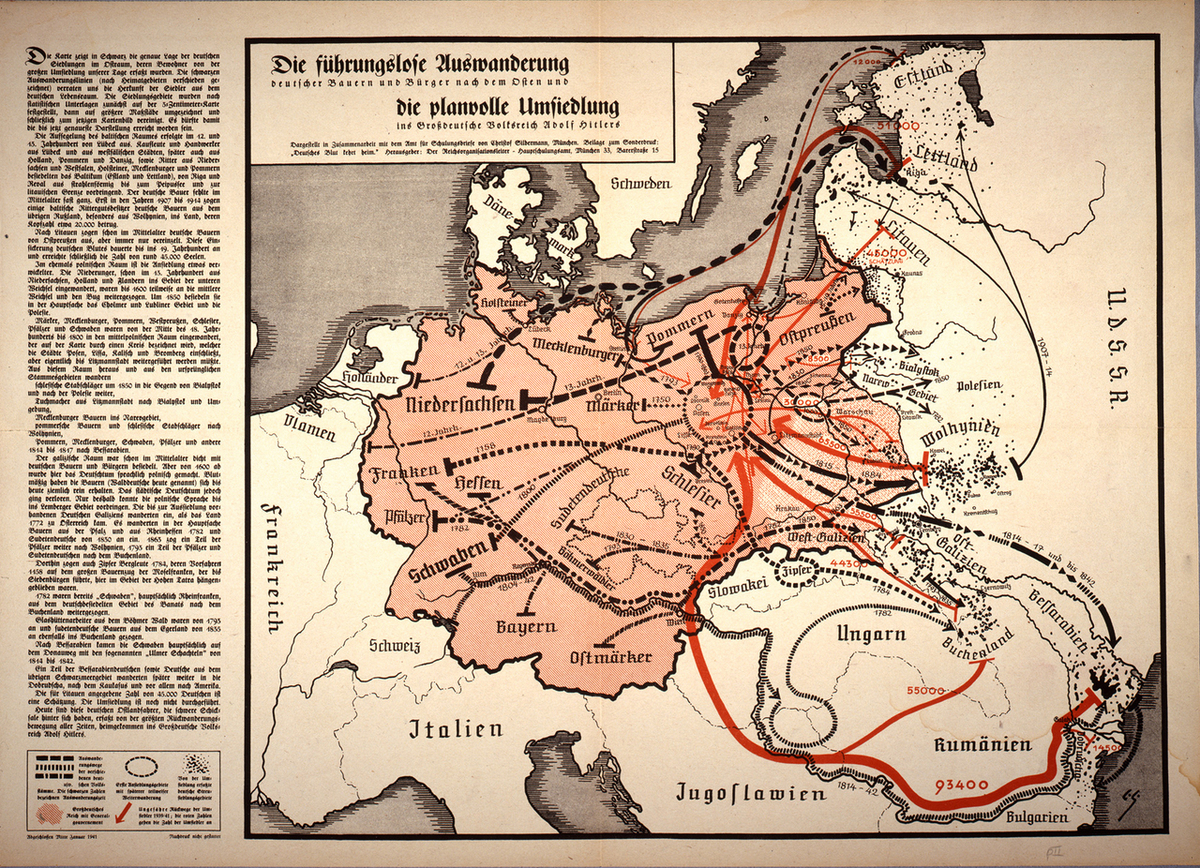
The exploration of the Baltic area by ship took place in the 12th and 13th century from Lübeck. Merchants and craftsmen from Lübeck and Westphalian cities, later also from Holland, Pomerania and Gdansk, as well as knights from Lower Saxony and Westphalia, Holsteiners, Mecklenburgers and Pomeranians settled in the Baltic States (Estonia and Latvia), moving outward from Riga and Reval to Lake Peipus and the Lithuanian border. The German peasant was almost completely absent here in the Middle Ages. It was only in the years 1907 to 1914 that some Baltic manor owners recruited German peasants from the rest of Russia, especially from Volhynia, whose headcount was about 20,000.
German peasants from East Prussia moved to Lithuania already in the Middle Ages, but always only in small numbers. This seeping in of German blood continued until the 19th century, eventually reaching the number of about 45,000 souls.
In the former Polish area the settlement is a bit more complicated. The Niederungers, who had migrated to the Lower Vistula region from Lower Saxony, Holland and Flanders as early as the 13th century, had partially moved on to the Middle Vistula and the Bug River by 1600. Around 1850 they settled mainly in the Cholm and Lublin area and Polesia.
Märkers, Mecklenburgers, Pomeranians, West Prussians, Silesians, Palatines and Swabians had migrated from the middle of the 18th century to 1800 to the central Polish area, which is indicated on the map by a circle that includes the cities of Posen, Lissa, Kalisch and Bromberg, but should actually continue to Litzmannstadt. From this area and from the original tribal areas:
Silesian forest workers migrated around 1850 to the area of Bialystok and to Polesia,
Clothiers from Litzmannstadt to Bialystok and its surroundings,
Mecklenburg peasants to the Narev region,
Pomeranian peasants and Silesian forest workers to Volhynia,
Pomeranians, Mecklenburgers, Swabians, Palatines and others to Bessarabia from 1814 to 1817.
The Galician region was densely populated with German peasants and citizens already in the Middle Ages. But from 1600 onwards the Germans were linguistically Polishized here. In terms of blood, the peasants (today called Forest Germans) have remained quite pure until today. In urban areas, however, Germanness was lost. Only because of this could the Polish language penetrate into the Lviv region. The Germans of Galicia who existed there before the resettlement had immigrated when the country became part of Austria in 1772. Mainly peasants from the Palatinate and Rheinhessen immigrated in 1782 and Sudeten Germans from 1830. In 1863 some of the Palatines moved on to Volhynia, in 1793 some of the Palatines and Sudeten Germans moved to Buchenland.
In 1784, Spiš miners, whose ancestors wound up here in the High Tatras in 1158 during the great peasant migration of the Moselle Franks leading all the way to Transylvania, also moved there.
In 1782, “Swabians,” mainly Rhine Franks, had already moved on from the German-settled area of the Banat to the Buchenland.
Glass workers from the Bohemian Forest had also moved to Buchenland from 1793, and Sudeten German peasants from Egerland from 1835.
The Swabians came to Bessarabia mainly via the Danube route on the so-called "Ulmer Schachteln" from 1814 to 1842.
A part of the Bessarabian Germans as well as Germans from the rest of the Black Sea region later migrated further to the Dobrudja, to the Caucasus and above all to America. The figure of 45,000 Germans given for Lithuania is an estimate. The resettlement has not yet been carried out. Today, these German Ostlanders, who have difficult fates behind them, are caught up in the greatest return migration of all times, and have come home to Adolf Hitler's Greater German Empire.
Legend (from left to right): Emigration routes of the various German tribes. The black numbers indicate emigration time.
First settlement areas with later partial onward migration.
German scattered settlement areas affected by resettlement.
Greater German Reich with General Government.
Approximate return routes of resettlers in 1939/41; the red numbers indicate the number of resettlers.
Source: Deutsches Historisches Museum, P 98/135. “ Die führungslose Auswanderung / deutscher Bauern und Bürger nach dem Osten und / die planvolle Umsiedlung ins Großdeutsche Volksreich Adolf Hitlers” [“The undirected eastward emigration of German peasants and citizens and the planned resettlement into Adolf Hitler's Greater German People's Empire”], Munich, 1941, Offset, 40,0 x 56,0.
© DHM