Map of Germania / Germany (1572)
Abstract
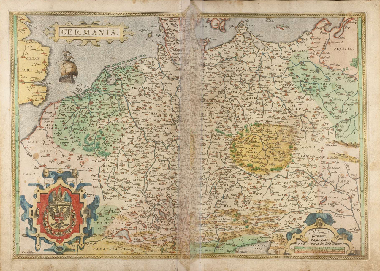
Abraham Ortelius’ map of Germany from his Theatrum Orbis Terrarum (1572) shows the Holy Roman Empire with the neighboring countries of France, England, Denmark, Prussia, Bohemia, and Hungary, which are denoted by color. The border crossings are lightly shaded in yellow. Bohemia, as the “heart” of Europe, is symbolically surrounded by trees and mountains. Within the Empire, towns, rivers, lakes, and the Alps are marked. The accompanying text explains that the Old Empire geographically encompassed areas where the German language was spoken. One special exception was Bohemia, where no German was spoken, but which belonged to the Empire in accordance with governing law.
Source
Germany. [Excerpt from page 13]
In Christendom, no larger or vaster country is encompassed under one name than Germany. Its width extends between the Alps, or the heights of the Italian mountains to the south, or meridiem, and the German or Baltic Sea in the north, or septentrional. Its length is such that it actually cannot be described, because it is not separated from neighboring countries by well-known mountains or bodies of water and for that reason has been divided differently by many and various writers and times. And for that reason it seems, to us, to be best and most comprehensible to resolve the matter with its own language: that is, we should call all of it (as far as the German language extends) Germany, and the countries that follow should be included, starting at the Occident, or sunset next to the ocean, to the Orient, or sunrise, where it ends, and from there again toward the land in the Occident, or sunset, and continuing to turn until we are at the end near the mountains, thus including first Flanders, then Brabant, Zealand, Holland, Friesland, Denmark. Mecklenburg, Pomerania, Prussia, the Old and New Marches, Saxony, Westphalia, Guelders, Cleves, Jülich, the Bishopric of Cologne, Hesse, Thuringia, Meissen, Lausnitz, Silesia, Moravia, Bohemia, Franconia, the Bishopric of Mainz, Luxemburg, the Bishopric of Trier, the Palgrave’s country, Alsace, Württemberg, Swabia, Bavaria, Austria, Styria, Carinthia, Tyrol, Switzerland, etc. And although German is not spoken in Bohemia, it is befitting for it to be rightly included, because it is surrounded by the German language and the king is one of the most prominent German lords, namely, one of the beloved electors. The German language is (as Doctor Johannes [Goropius] Becanus confirms) the first and oldest language spoken in the world. This country is very honored with the title of the Roman Empire; it is very delightful in all things; a fruitful country, having many ships, it is supplied with water from many famous rivers, namely, the Rhine, the Elbe, and the Donau, etc., which are the most important rivers in Europe, and it is populated with a large number of peoples and splendid cities. No country in Europe is richer in mines and ores, such as gold, silver, copper, iron, tin, and lead. This country has all the amber that is to be found anywhere. The city of Nuremberg is considered to occupy the middle and is the highest in the country.
The inhabitants are quite large in stature or build, strong in body, upright in disposition (not deceptive), and skillful handworkers; as a result, they are inventors in many fields, such as printing, guns, sundials, and clockwork, etc. They are good soldiers on foot and on horseback. They are hospitable and enjoy hospitality, despite the fact that the opposite is generally said of them; the fact that other nations are praised for hospitality happens (it seems to us), as other countries that do not receive glory and praise have seen, more because of stinginess with money and the hope to benefit from foreigners than for other reasons. And to accurately judge the correct reason, we find in our opinion that there is more help for foreigners in Germany than elsewhere. But just as that is no license, [the Germans] are too often very inclined to drink, and although a number of other countries have exhibited that [behavior] and in the old days transgressed in that area, for example, the Greeks, and also among the Romans -- there are many stories of partly great drunkards -- the Germans surpass and go beyond all of them, which would not be held against them if they abstained from doing it. But because their heads hurt from it and are hard to cure, we intend out of mercy to put a plaster on it, which is this, that of all the names thrown at many countries (which we do not wish to list here, for our behavior is not to be reviled), this seems to be the least objectionable, because it does the least harm to the next person.
Translation: Kathleen Dell’Orto
Source: Abraham Ortelius, Theatrum oder Schawplatz des erdbodems: warin die Landttafell der gantzen weldt, mit sambt aine der selben kurtze erklarung zu sehen ist. [S.l.]: Autor, 1572. Herzog August Bibliothek, Wolfenbüttel. Images 66 and 67 combined and cropped. Available online at: http://diglib.hab.de/drucke/2-1-1-geogr-2f/start.htm?image=00066 and http://diglib.hab.de/drucke/2-1-1-geogr-2f/start.htm?image=00067
This work is licensed under the Creative Commons Attribution-ShareAlike 4.0 License.
Further Reading
Peter Meurer, “Abraham Ortelius’ Concept and Map of Germania,” in Marcel P. R. van den Broecke, ed., Abraham Ortelius and the First Atlas: Essays Commemorating the Quadricentennial of his Death, 1598-1998. Utrecht: HES-Publ., 1998, pp. 263-70.
Andreas Rutz, Die Beschreibung des Raums. Territoriale Grenzziehungen im Heiligen Römischen Reich (Norm und Struktur 47). Böhlau: Cologne/Weimar/Vienna, 2018.